Description of the Demonstrator
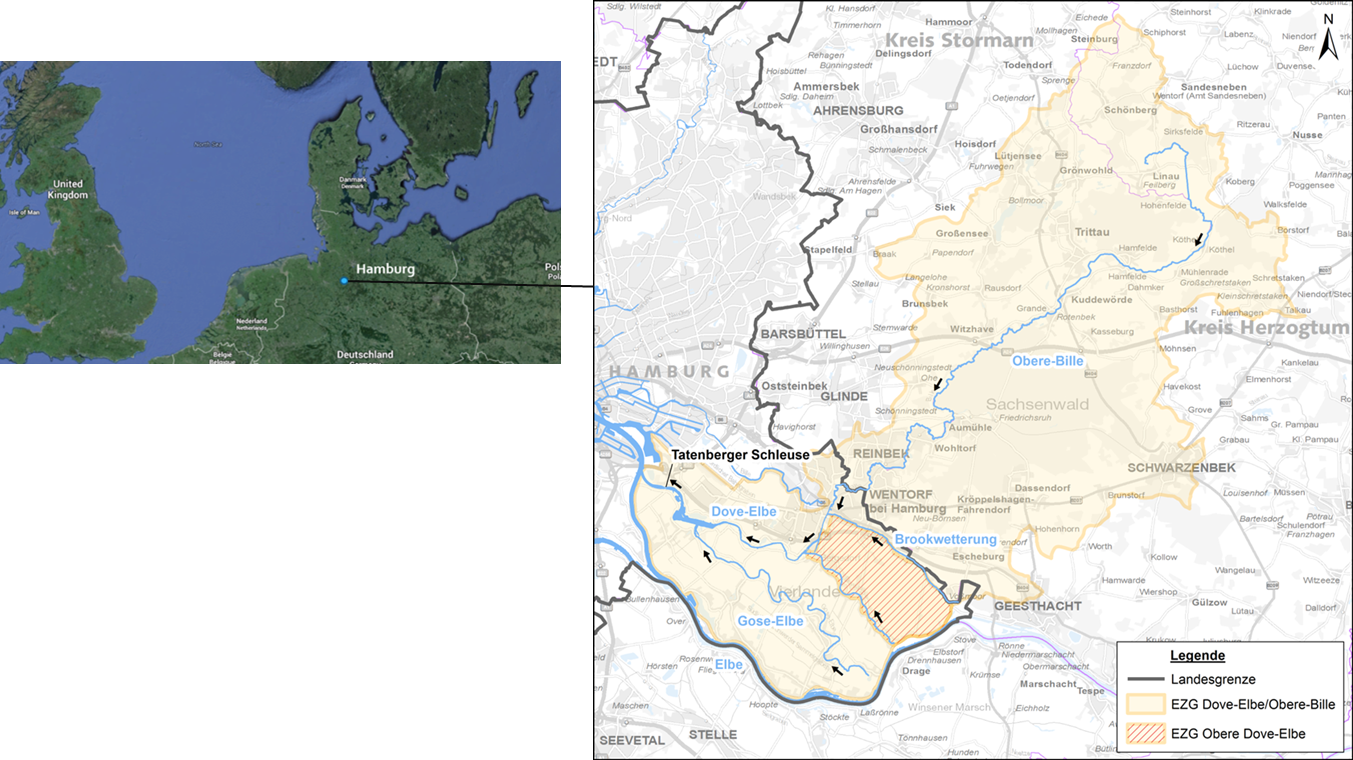
The river system of Dove and Gose Elbe, Germany, located in the southeastern part of the City of Hamburg, formerly part of the inland delta of the Elbe river with marsh characteristics, is nowadays protected by flood protection measures from the tide influenced Elbe estuary.
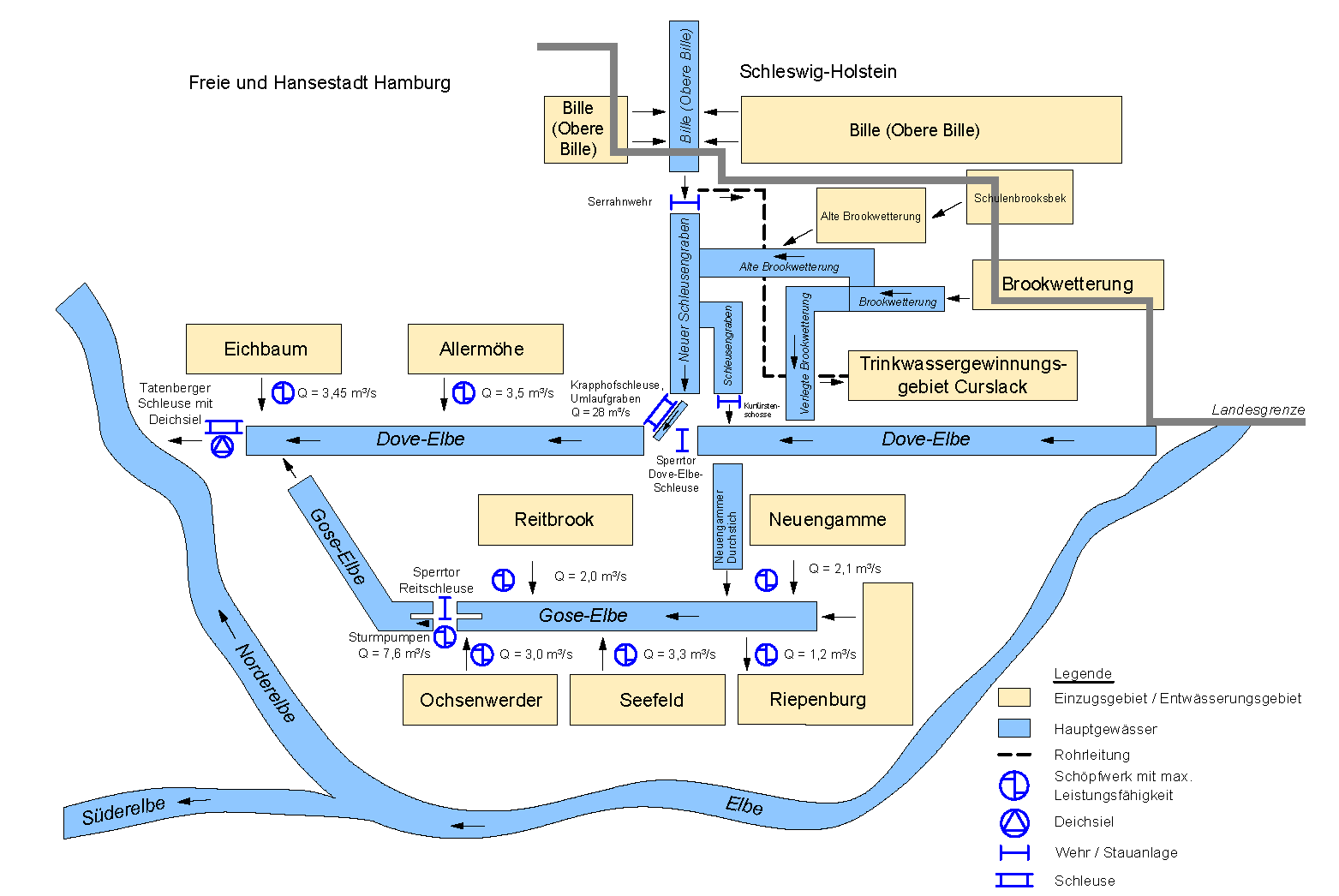
This river system is a part of the complex drainage system of the area Vier- und Marschlande, which also includes the river Bille and the surface waters of Schleusengraben as well as the Old and New Brookwetterung (Drainagesystem) in addition to the Dove and Gose Elbe catchment areas.
The two main rivers of the system – Dove and Gose Elbe – are branches of the Elbe River that have been hydraulically decoupled from Elbe River by dikes and sluices. In order to regulate the water levels within the drainage area, a highly complex monitoring and control system consisting of three main rivers, other smaller rivers, numerous ditches, pumps and water management facilities, has been developed over time.
Context
Environmental and Geographic context, climate conditions and problem description concerning hydro-meterological risks.
Floods (affecting mainly settlement areas and agriculture) due to the combination of:
- High water levels in the Elbe River over a longer period (several days) due to wind from western directions.
- High discharges within the river system Dove/Gose Elbe and its tributaries (Bille) due to continuous rainfall over a longer period (several days)
Droughts (affecting mainly agriculture, water extraction, biodiversity, locking operation for shipping purposes) from low water levels due to the combination of:
- Low water levels in the Elbe River over a longer period (several weeks) due to i) low inland runoff and ii) wind from eastern directions.
- Low discharges within the river system Dove/Gose Elbe and its tributaries (Bille) due to long droughts (several weeks)
Find out more in this article
Implementation
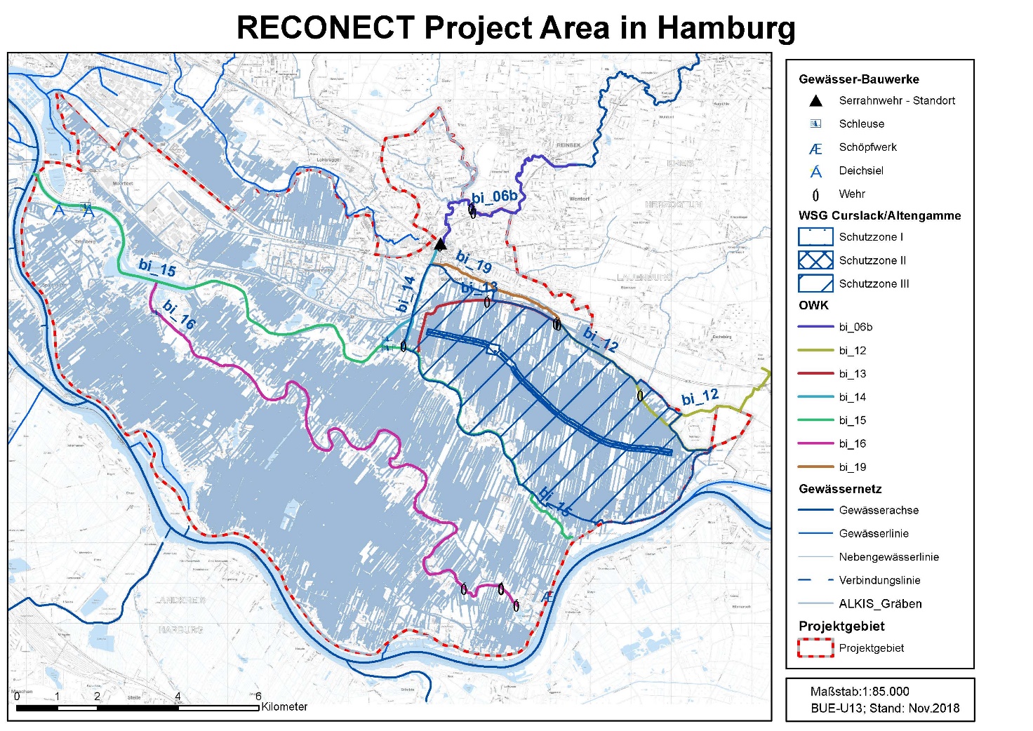
The main goal of the demonstration activities is the reactivation of the storage capacity of the rivers Bille, Dove and Gose Elbe, their tributaries and trenches (such as, Brookwetterung, Curslack) and their flood plains in the area of 110 km2, to create more retention volume for water during flooding. At the same time necessary stable water levels in the rivers can be provided during droughts.
The functional NBS components will be (natural) floodplains and (natural) storages.
The (improved) Bille, Dove and Gose Elbe monitoring and control system will focus on:
- The conversion of grey infrastructure into hybrid solutions
- The expansion of the existing linear and disciplinary approach into a holistic approach
- Reducing risk to hydro-meteorological events:
– Rainfall – river flooding
– Droughts => re-direction of water supply to area
– Coastal / estuarial flooding
-Continuous functioning of the fish ladders and passages - Increasing biodiversity, Contribution to development Goals of the Water Framework Directive (2000/60/EC)
- Positive impact on economic (agriculture, drinking water supply for Hamburg – groundwater wells)
- Innovation by combination of droughts and flooding aspects
- Installation/Construction (FHH):
– Ministry of Energy and Environment (FHH-BUE)
– Agency for Roads, Bridges and Waterways (FHH-LSBG)
– Hamburg City District of Bergedorf - Monitoring (FHH):
– Ministry of Energy and Environment (FHH-BUE)
– Agency for Roads, Bridges and Waterways (FHH-LSBG)
– Hamburg City District of Bergedorf - Scientific support: TUHH
- Dissemination and Upscaling: Senate Chancellery (FHH-SK)
Nature based restoration of landscape to manage floods and droughts utilising innovative controlling and operation of the water volume in the Bille and Dove/Gose Elbe river system.
Upscaling possible within the Northern EU and beyond.