Description of the Demonstrator
The river Thur is prone to flooding.
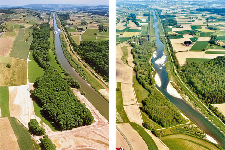
Recently, various NBS river restoration measures have been proposed and established aiming at improving not only flood protection but also the ecological status of the river and the riparian zone.
Context
Environmental and Geographic context, climate conditions and problem description concerning hydro-meterological risks.
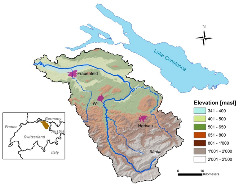
The river Thur is located in NE Switzerland, draining the front ranges of the Swiss NE Limestone Alps (S of the Lake Constance basin).
It is a tributary of the river Rhine which flows into the North Sea. The river Thur is the largest Swiss river without a natural or artificial reservoir and exhibits discharge and water level fluctuations similar to unregulated alpine rivers: low discharge: 3 m3s-1; annual mean discharge: 23.3 – 76.4 m3s-1; peak flows up to 1100 m3s-1.
Snowmelt and strong rainfall events in the pre-alpine headwaters cause a rapid increase of discharge. The Thur catchment is prone to flood-related problems and has very sensitive areas (e.g. urbanized areas with industries and camping sites).
To reduce the risk of flooding, various NBS have been already implemented or are under construction throughout the catchment. In this sense, the river Thur flood risk management plan, focusing on NBS as priority actions, is a good example of the implementation of the EU Flood Directive 2007/60/EC to mitigate flood risks.
Implementation
The existing hydraulic measures, work currently underway, as well as additionally planned actions in the flood risk management plan, have been evaluated in terms of economic, ecological and hydraulic impact.
Examples for such measures are river restoration projects, construction of retention areas for flood protection and artificial groundwater recharge. All actions are planned to better distribute the water to reduce flood risks and also to provide enough water during dry periods. These actions are imbedded within the implementation of the Swiss Federal law to revitalise 4000 km of river water courses within the next 80 years. These are sorted according to a ranking using economic, ecological and hydraulic considerations.
The evaluation scheme was developed at Eawag and will be made available to the entire RECONECT consortium.
The existing NBS have their main impact in terms of flood risk management.
Examples of such measures are river restoration projects, construction of retention areas for flood protection, and artificial groundwater recharge. In addition to the flood risk mitigation objective, the ecological status of the restored river reaches was improved, which consequently led to a significant increase of recreational activities.
Technical and administrative key actors: Swiss Federal Office for the Environment (FOEN), Agency for the Environment of Canton Thurgau, Agency for the Environment of Canton Zurich, Agency for the Environment of Canton St. Gallen.
Scientific key actors: Eawag (Swiss Federal Institute of Aquatic Science and Technology)
In Switzerland, river restoration for the improvement of the ecosystem and flood prevention is a national priority task, implemented by the Federal government, the Cantons and Municipalities. The actions required for the implementations are binding by Swiss Federal law.
The law defines that over the next 80 years, 4000 km of water courses within Switzerland need to be restored. This results in a large potential for implementation of the measures deployed in the Thur catchment on other catchments and countries.