Description of the Demonstrator
Following the storm Xynthia in 2010, the municipality of Châtelaillon-Plage has set up, with the municipality of Yves, Aix and Fouras, a system to fight against different types of flood called PAPI (Program of Actions Of Flood Prevention).
The purpose of this system is to protect people, goods and activities against the risk of marine flooding. The various actions are carried out within mentioned PAPI action plan. The three major themes are taken into account: (i) Prevention and forecasting with improved knowledge and awareness of risk, surveillance, flood and flood forecasting, crisis alert and management, (ii) spatial planning where risk is taken into account along with actions to reduce the vulnerability of property and people and (iii) the works of protection. They included flow management (from the sea and marshes), creation of protective structures (e.g., breakwater, enhancement and thickening of existing coastal structures).
The structures are designed to withstand a more important event than Xynthia (Xynthia + 20cm). The nature of NBS activities are focused on: (i) regeneration of multi-purpose wetlands (oyster farming risk reduction) and (ii) engineering solutions (hybrid configuration).
Context
Environmental and Geographic context, climate conditions and problem description concerning hydro-meterological risks.
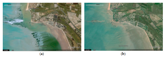
“Les Boucholeurs” is a district of Châtelaillon-Plage located on the limit of Yves, two cities of the Charente-Maritime county.
This district count approximately 600 houses and have an important activity in oyster and mussel farming. Les Boucholeurs extends in border of a vast bay and presents houses on the sea front directly exposed to waves as well as setback constructions on the location of former leveed marshes. Storm Xynthia that occured in 2010 caused a lot of damages.
In Les Boucholeurs, the urbanized zone has undergone both, north, overtopping on the sea front (the strong exposure to waves caused two deaths) and, south, water entrances on a very large linear due to levees and dunes overflowing. The canal that crosses the urbanized area (The Punay port canal) contributed to store the water in the high stakes zone. The foreshore ramps were not equipped with locking devices and allowed the passage of large flows.
The lighter marshes were severely damaged after being submerged. However, the permeability of road and railway infrastructures allowed a part of the water to spread outside the most vulnerable areas.
Implementation
- Marine flood reduction focusing on embankment system. The new protection level. .
- Authenticity of the area and preservation of existing buffer zone (retention areas)
- Social, economic or ecologic
- Local municipality, Châtelaillon-Plage and the mayor’s office.
- The local society SILYCAF (Syndicat du Littoral Yves- Châtelaillon-Aix-Fouras), established after Xynthia as a public structure for the protection of persons and property against the risks of marine submersion.
- Highly sensitive area (after Xynthia) with strong social component. The people in this area suffered a lot and the new governmental solutions were not accepted.
- Combining NBS and post disaster recovery focusing on new solutions that will focus on raising awareness.
- Up scaling along the Atlantic coastline
https://www.chatelaillonplage.fr/
Les Boucholeurs case study from PEARL FP7 project:
http://www.pearl-fp7.eu/casestudies/france/